Saturday, April 23, 2022

365 Days of Climate Awareness 253 - Deforestation of the Amazon


Sorry so late! I move not too long ago, then got sick. It all finally caught up to me. Better late than never! Enjoy--

The Amazon rainforest is the tropical, broadleaf forest which covers most of the 7 million km2/2.7 million mi2 drainage basin of the Amazon River in South America. Of this the forest covers 5.5 million km2/2.1 million mi2,or 79% of the basin (roughly the size of the continental US!) It stretches through nine countries (60% in Brazil, 13% in Chile, 10% in Ecuador, and smaller amounts in other countries) and 3344 indigenous tribal areas. However, in recent decades the existence of the rainforest, despite all its environmental and cultural importance, has come increasingly under threat from deforestation driven mostly by agriculture, particularly cattle farming.


Amazon forest loss.

Before the 1960’s the rainforest was largely untouched, before Brazil in particular (followed by Bolivia) began developing its farming, cattle and logging industries. While the tropical warmth is conducive to many crops and animals, it was surprisingly found that cleared rainforest did not reveal rich, loamy soil underneath, but highly weathered laterite–clay of the sort used for bricks–due to the extreme amounts of rain. The organic cover was itself removed with the trees and plants. Despite the lower-than-expected value of the cleared land, the practice has accelerated. Though clearance rates decreased by nearly 80% between 2005 and 2012, in recent years Brazil has stepped its forest clearance activities back up to earlier rates–
7,900 km2 /3,050 mi2 in from August 2017 through July 2018. It is estimated that as much as 25% of the original rainforest has been cleared in Brazil and other countries, and if current rates continue, that could reach 40%--by 2030, leaving only 3.3 million km2/1.3 million mi2. 


South America forest loss.

Climate modelers predict that forest loss of that amount will permanently alter the regional climate in the eastern part of the current rainforest, converting it to savanna like those farther east in Brazil. The forest itself is an important climate driver, with evapotranspiration–seasonally varying absorption and re-emission (transpiration) of water by plants, plus evaporation from soil–-controlling the monsoonal rains. Removal of enough forest will end this cycle and lead to year-round arid conditions. The aridification is likely to worsen as more forest is removed. Climate scientists estimate that deforestation activities account for nearly one-third of global CO2 emissions, and that halting them would be a major step toward climate sustainability.


Global map of evapotranspiration. Note centering on the equator, with especially large region in South America.

30 million native inhabitants are estimated to live in the 3344 indigenous areas within the rainforest, and ongoing deforestation amounts to a genocide akin to the spread of white society across North America in the 1800s. Loggers have killed natives. While most forest clearance has so far been done in non-indigenous zones, that buffer is shrinking. The Brazilian government recently declared by fiat that its agricultural ministry will administer all Amazon indigenous zones within its borders. The way has been cleared for economic development to roll over the human rights of native inhabitants of the Amazon.


Cleared forest in Brazil.

Tomorrow: the cattle industry and global warming.


Be brave, and be well.


Thursday, April 21, 2022

365 Days of Climate Awareness 252 – Brazil and Climate Change


Leading South America economically as it does, Brazil is the continent’s major emitter of carbon dioxide, and is also one of the world’s leading culprits of ongoing deforestation, reducing its value as a CO2 sink, and converting that same land to more carbon-intensive uses such as livestock farming and industry. Ongoing political instability has not helped, since industry and profiteering individuals have had a freer hand than they would otherwise. Brazil’s economy is the 12th largest in the world by GDP, though it is still classified as developing. It is one of the nations whose rush to catch up to the already-industrialized nations of North America and Europe have led it into a headlong, frequently haphazard, and occasionally ruinous course of economic development.


Emissions come from a variety of sources in an economy as diverse as Brazil. It is estimated that in 2016, 33.2% of carbon dioxide emissions came from agriculture, 28.9% from the energy industry, and 27.1% from land use change (loss of CO2 sinks due to deforestation and landscaping) and forestry. The majority of emissions within the energy industry is from transportation, which is commonly the case for industrialized nations.


Annual CO2 emissions, Brazil, 1901 - 2021


Cumulative CO2 emissions, Brazil, 1901 - 2021

Brazil’s climate is predicted to remain fairly stable through the 21st century, which is common among tropical nations, with some overall reduction in rainfall. Temperatures, particularly at night, are expected to warm. The arid northeast is modeled to become more arid, with the appearance of some desert zones. The monsoonal and rainforest will not disappear but are expected to shrink, though this expectation is based partly on current patterns of aggressive deforestation. The forest and plant cover in northern Brazil plays a major role in the local climate, as evapotranspiration—the absorption of water by plants, and its later evaporation—directs the monsoonal winds and affects weather patterns throughout and beyond the region. Forest loss weakens the entire cycle and leads to less precipitation overall.


Per capita CO2 emissions, Brazil, 1901 - 2021

Tomorrow: Amazon deforestation.

Be brave, and be well.

Wednesday, April 20, 2022

365 Days of Climate Awareness 251 – Introduction to Brazil


Brazil dominates South America, in both area and population. At 8.5 million km2/3.3 million mi2, Brazil constitutes 49% of the continent’s area. With 211 million people, Brazilians make up nearly 50% of South America’s population. Its GDP of $3.585 T is likewise 49% of the South American total of $7.27 T. Though the Amazon River starts farther west with tributaries in Peru, and its drainage basin reaches to the peaks of the Andes, most of basin lies within Brazil. Physically, economically and in population Brazil dominates South America.


Prehistoric remains of humans in South America were found in Brazil and date as far back as 11,000 years BP. Several cultures existed through the millennia there before the Portuguese encountered the Marajoara people in the 1400’s. After the 1494 Treaty of Tordesillas between Portugal and Spain, Portugal claimed Brazil and began colonizing. During the wars with Napoleon, the Portuguese court relocated to Rio de Janeiro, to escape the threat of the French army. When the court attempted to return to Portugal in 1821, the former colony began moving toward independence, which Portugal recognized in 1825, though the Brazilian state was still dominated by Portuguese.  Attempts at republican government in the 1800’s were largely military dictatorships, though a more genuine democracy took power in 1894 and survived until 1930. Since then Brazil has endured a turbulent series of dictatorships until the 2000’s, when peaceful transfers of power between elected successors started becoming the norm, though with a government marred by widespread corruption and elections featuring extensive violence. Brazil’s current president, Jair Bolsonaro, has stated that he will not respect any result where he is not the winner.


It extends from 10°N latitude to 35°S, and from 35° to 74° W longitude. More than three-quarters of the country’s area is tropical, including much of the Serra do Mar, the mountains on Brazil’s southeast coast. Rainforest and monsoonal forest comprise roughly the northern third of the country, with about half, the central region, is savanna. There is little climatic variation in temperature in the tropical zone, though the monsoon brings seasonal rain. South of the Tropic of Capricorn temperatures are still mild, though frost does occur during austral winter (June-September). The lowest officially recorded temperature in Brazil is -14°C/7°F. Precipitation in the Amazon region is consistent and yearlong, while farther south the climate is dry from late austral fall to spring (May through November), and rainy during austral summer (December through April). The northeastern region is semiarid, and rain is irregular.


Amazon River.

Brazil’s biodiversity, especially in the Amazon region, is tremendous. Different climatic zones and ecosystems support many different large mammals, primates, and hundreds of types of birds. It is estimated that 4 million species live in the country. Among the many industries within Brazil’s economy, agriculture poses the most direct  threat to the Amazon rainforest, with forest clearing which has continued without a break (though at varying rates) for more than three decades. Brazil is among the world leaders in production of beef, chicken meat, milk, pork, and eggs. Brazil is the second leading exporter of iron ore globally, and 30% of its economy is based on manufacturing of cars, aircraft, computer parts and other goods. It also has a thriving oil industry, especially offshore, and is the world’s tenth-leading producer of crude oil at 2.8 million b/d.


Serra do Mar range.

Tomorrow: Brazil and climate change.

Be brave, and be well.

Tuesday, April 19, 2022

365 Days of Climate Awareness 250 – South America and Climate Change


There are a number of increasingly serious effects of global warming across the continent of South America right now, in addition to the trends which are almost certain to become more severe in years to come. As is usually the case, climatic effects are worsened by human activities which amplify and extend them. Prime examples of this are the forest fires which have blazed through the Amazon rainforest since 2019.


Amazon wildfire, 2019

Several ruinous trends have converged to form this crisis. First, and fundamentally, is the ongoing warming of the planet, which has raised temperatures in the air, ocean, and soil. While the increased heat has amplified the water cycle, leading to more rain in many places on earth, at the same time it has made weather patterns less predictable, leading to more droughts in those same areas, increasing the overall likelihood of forest fires. Second is the ongoing deforestation of the Amazon, which has been happening for decades, as Brazil increases its agriculture and industry. In many cases fires are set deliberately as the least expensive, most efficient method of clearing land.


Lake Poopo by satellite, 2004 (left) vs. 2016 (right)

Third, and most specifically, was the 2018 election of right-wing ideologue Jair Bolsonaro to the Brazilian presidency. He has pursued an outright murderous policy toward the Amazon and its inhabitants, encouraging increased burning and land clearing. He began firefighting efforts, reluctantly, only in September 2019 after months of increasing public pressure.  A few short years later—2022--extreme amounts of rain swelled several rivers in Brazil and flooded several cities such as Jordao and Petropolis.


Lake Poopo, recently, up close

Water scarcity is becoming a reality throughout the continent, not only in Brazil, but elsewhere. In 2014 water reserves for São Paolo, the largest city in Brazil, dropped below 10%. Cities and towns in Peru and Colombia have also faced water shortages in recent years. And like the Aral Sea in Asia, Lake Poopo, formerly the second-largest lake in Bolivia, has gone dry. This is due partly to decreased rain, and partly to diversion of water for irrigation projects. Increased heat and decreased precipitation has forced the evacuation of several native tribes from the savannas of Guyana.


Hurricane Catarina, 2004, approcahing Brazil

The South Atlantic, not known for cyclones, is producing a growing number of tropical storms. Since 2004, when the first-ever recorded South Atlantic hurricane, Catarina, came ashore, several cyclones have formed there. Conditions in the South Atlantic are not conducive to hurricane formation. Due to large-scale circulation patterns, the surface water is generally cool, and the tropospheric wind shear—differences in velocity and direction with height—is high enough to prevent the strong vertical convection necessary for a large storm to form. But as the ocean and air continue to warm, conditions are increasingly ripe for more to do just that.


Petropolis, 2022

Tomorrow: introduction to Brazil.

Be brave, and be well.

Monday, April 18, 2022

365 Days of Climate Awareness 249 – Introduction to South America


The continent of South America sits in the western hemisphere and straddles the Equator, though it is mostly to the south. It is comprised of twelve countries, two of which, Bolivia and Paraguay, are landlocked. It covers 17,840,000 km2/6,890,000 mi2, and has a population of over 423 million, roughly 5% of the world’s population. As with many other regions on earth, the bulk of the continent’s population lives near the coast, with the inland populated comparatively sparsely.


The west coast is an active tectonic margin, with the Pacific plate diving beneath the continent, creating the volcanic Andes Mountains along most of its length. The east coast by contrast is a passive margin, descending more smoothly into the Atlantic with the nearest oceanic ridge more than a thousand miles away. The north coast is more active tectonically, with smaller plates in the Caribbean creating volcanoes and earthquake activity on a regular basis.


More than one half of South America is tropical and dominated by rain forest in the northern and central regions, with temperate and cooler climates further south and at higher elevations. The margin between South and Central America is the boundary between Colombia and Panama. Although plant growth is lush throughout most of the continent, deserts occur in the central west along the coasts of southern Peru and northern Chile, and east of the Andes in Argentina.

Economically South America is less dependent on exports than other continents, both of raw materials and finished goods. Oil is a major product of Brazil (10th leading producer globally, 28 million b/d), Venezuela (21st leading producer, 877,000 b/d), Colombia (22nd, 866,000 b/d), and Ecuador (28th, 531,000 b/d). Though Brazil is one of the world’s major economies, and  the country is quite industrialized, its government and economy continue to struggle and most of South America is classified as developing. For this reason they tend to pursue aggressive programs of economic development with little regard to environmental cost.

Tomorrow: climate issues facing South America.

Be brave, and be well.

Sunday, April 17, 2022

365 Days of Climate Awareness 248 - Kenya and Climate Change


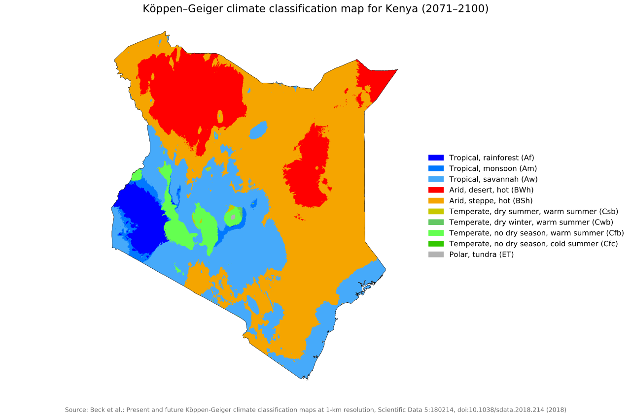
As with many other African nations in already arid zones, water scarcity is the main threat posed by global warming in Kenya. Mean temperature in Kenya has risen fairly consistently with the rest of the planet over the past century, roughly 1°C/1.8°F, and is projected to continue. As is the pattern elsewhere on the globe, increased temperature will accelerate the water cycle, making wet regions wetter and dry regions drier. For Kenya this is projected to bring more rain, with the rainforest expanding and desert regions actually shrinking.


Köppen-Geiger climate zones 1980-2016


Predicted Köppen-Geiger climate zones, 2071 - 2100

Despite this, it will become increasingly difficult for Kenya’s best-known macrofauna, such as lions, leopards and elephants to survive as their habitat shrinks between the forest and the dry zone with warming temperatures. Furthermore, Kenya’s already precarious agriculture industry, suffering already from periodic droughts and inconsistent production, will suffer as well. 
Lake Turkana, in the northwestern part of the country near Ethiopia, is in danger of drying up as that portion of Africa is expected to warm much more quickly than surrounding areas in the coming century. 


Temperature anomaly, Kenya, 1951 - 2011


Annual CO2 emissions, Kenya, 1950 - 2021

The short rains from October to December have been becoming longer and more intense. Models predict this trend to continue, with erosion and flooding becoming an increasing problem. This is the conundrum around the world: increasing precipitation with increased warmth does not imply good growing conditions, as the higher levels of rain are likelier to have catastrophic, and not always beneficial, effects. In addition, sea-level rise is likely to inhibit growth in the coral reefs and mangroves along the coast. 


Cumulative CO2 emissions, Kenya, 1950 - 2021


Per capita CO2 emissions, Kenya, 1950 - 2021.

As so many other developing countries with medium-sized economies–which describes most of Africa–Kenya is caught in a trap not of its own making. How best to manage the coming change without further destroying its own environment, for example by clearing forest for additional farmland, is the nearly impossible challenge faced by an inefficient government too often at the mercy of both global economic and local social interests.


Tomorrow: introduction to South America.


Be brave, and be well.


Saturday, April 16, 2022

365 Days of Climate Awareness 247 - Introduction to Kenya


Kenya is a country on the east coast of Africa, south of the horn, with a population of roughly 48 million, and covering 580,367 km2/(224,081 mi2. Its capital and largest city is Nairobi, and its second-largest, and previous capital, is Mombasa. Kenya is extremely diverse geographically, ranging from snow-capped mountains, to subtropical forest, to savanna and desert. While the country has regularly grown economically, that growth has been stunted by pervasive corruption throughout the government, which has left a large segment of the population in poverty.


Physical and political map.

Kenya’s fossil record is one of the most extensive on earth, including primates dating to 20 MYA, and early hominids (Homo habilis, Homo erectus and others) dating to 1.5-2 MYA. Homo sapiens appeared as early as 320,000 BCE. Hunter-gatherers gave way to farming societies, which, along with the discovery of metals, led to regional and maritime trade. Germany and Britain began colonizing the area in the late 1880’s, with Germany ceding their holdings to Britain in 1890. The British retained control until 1963 when, after nearly ten years of unrest including the Mau Mau rebellion, the Kenyans declared their independence and in 1964 established a constitutional republic.


Köppen-Geiger climate zones 1980-2016

Kenya straddles the equator, extending to 5°N/S. Its climate ranges from tropical, along the coast, to temperate, particularly in the mountains, to desert conditions in the northeast nearing the horn. There are two rainy seasons per year, the long rains which last from March to June, and the short rains, which last from October to December. Temperatures are warm throughout the year, during rainy and dry seasons. The country is home to hugely diverse ecosystems, including some of Africa’s most iconic land species: lions, leopards, buffalo, rhinoceroses and elephants. 


Nairobi

Telecommunications and finance comprise 62% of Kenya’s GDP, and agriculture another 22%. Most Kenyans–75%--are engaged in farming, but irrigation difficulties make this sector unstable. Manufacturing and other industries make up 16% of the economy. Kenya has a well-developed educational system based less on western-style choice and more on aiming students toward a target economic role.


Mount Kenya.

Tomorrow: Kenya and climate change.


Be brave, and be well.


Not-Quite-Daily Climate Awareness The Inflation Reduction Act of 2022

(It might take me a while to find a workable new title. Bear with me.) Now that US President Joe Biden has signed the Inflation Reduction Ac...