Monday, January 31, 2022

365 Days of Climate Awareness 172 – 2019 State of the World Climate


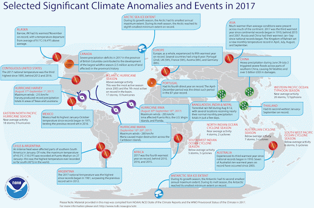
2019 World Climate Data

  • Global atmospheric CO2 concentration: 410.07 ppm, +2.45 ppm from 2018
  • Surface air temperature anomaly: +0.95°C/1.71°F, 3rd all-time 1880-2021
  • Precipitation 22.5 (0.4 in) mm below 1961-1990 global average 1033 mm (40.7 in)
  • Global mean sea level 55.59 mm above 1993-2008 average, +7.07 mm from 2018
  • Antarctic ozone hole: max. area 16.4 million km2; minimum O3 120 DU (Dobson Units)
  • ENSO: Weak El Niño early, neutral the rest of the year
  • NAO: Positive  (warmer in southeastern US and northern Europe; cooler in northeastern Canada and southern Europe)


Global Conditions

  • Above-average temperatures:  The Caribbean; South America; eastern, central and southernAfrica; western Indian Ocean islands; Europe; the Middle East; Russia; Siberia; Mongolia; central China; Japan; Micronesia; Australia
  • Below-average temperatures: Northwestern Africa
  • Above-average precipitation: Peru; the Amazon Basin; central and eastern Africa; northwestern Russia; northwestern China; India; Pakistan; Iran; north central and northeastern Australia
  • Below-average precipitation: The Caribbean; eastern and southern  South America; the Niger River delta region; southern Africa; western Indian Ocean islands; the Iberian Peninsula; the Middle East; southern Australia


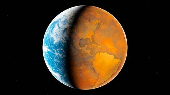
Carbon occurs in permafrost in two main forms: methane (CH4) and carbon dioxide (CO2). Methane tends to occur as the result of the anoxic breakdown of organic material, while carbon dioxide occurs with the oxidation of organic materials. Those are two very different types of process but both have produced huge reserves of greenhouse gases now locked in the permafrost of the north. In the shallower soil zones, where oxygen reaches, both can reside but carbon dioxide fluxes are the main concern of researchers.


A recent estimate of the amount of carbon stored in the soil of the continents—not the Arctic Ocean floor—is 1460-1600  Pg (Petagram = 1015 grams = 1 million billion grams = 1 million metric tons). Of that, 50-75% is estimated to be within 3 m of the surface. (Soil in the top 3 m of the rest of the planet is estimated to store about 2050 Pg C.) Through NASA’s satellite monitoring program it has been estimated that the circumpolar permafrost region is now a net carbon source into the atmosphere, of 0.3 Pg C per year. Throughout recent geological history the Arctic has tended to be a carbon sink. According to NASA’s data, the threshold has been crossed in the Arctic, from sink to source.


Organic Carbon Reservoir, Top 3 m of Arctic Soil

Tomorrow: 2020 state of the climate, North America.

Be brave, and be well.

Sunday, January 30, 2022

365 Days of Climate Awareness 171 – 2019 State of the Climate, North America


2019 US Climate Data

  • Global atmospheric CO2 concentration: 410.07 ppm, +2.45 ppm from 2018
  • Average air temperature: 54.2°F, 48th all-time 1895-2021
  • Average precipitation: 34.82”, +4.88” over mean
  • Tornadoes: 1517, 178 (24%) above the 1991-2010 average 1251
  • 18 named tropical cyclones: 6 hurricanes, 3 major (winds > 111 mph, 3-5 Saffir-Simpson)
  • Atlantic ACE: 143.78 x 10⁴ kts2 (1991 - 2020 mean: 108.7 x 10⁴ kts2)
  • ENSO: Weak E. Niño early, neutral the rest of the year


North American Conditions

  • Warmer than average: Northern Canada (above 60°N); southeastern US; Mexico
  • Cooler than average: Southern Canada (below 60°N); upper midwestern US
  • Drier than average: Northwestern and central southern US; northeastern, central and southern Mexico
  • Wetter than average: Midwestern and southwestern US; northwestern Mexico
  • Wildfires: Below average in Canada and the US
  • Snow cover: 25.4 x 10⁶ km2 winter maximum vs 1966 - 2020 average 25.1 x 10⁶ km2

The Atlantic hurricane season was again above-average in both storm count (18 vs. 12.1 average 1981-2010) and ACE (143 vs 104 x 104 kts2 1981-2010 average). Most of the storms were brief and unusually far north. Tropical Atlantic sea surface temperatures (SSTs) fluctuated around their long-term means all year but warmed a bit in late summer and fall with the emergence of an Atlantic Niño.


A series of severe spring floods struck eastern Canada along the Ottawa and St. Lawrence Rivers. The 2018-19 winter was unusually cold, leading to a very deep frost which did not thaw by spring, so the deep snowpack did not infiltrate the ground as it melted. In addition 1.5 m of rain fell on the region in April and May. These combined influences caused the rivers to overflow, killing two and damaging more than 6000 homes. Flooding also occurred in New Brunswick, leading to 5500 homes damaged or threatened.


2019 US Percentage Area Very Warm vs Very Cold (top 10th percentile for each).  

Permafrost responds to surface temperature variations in two principal modes. The first mode is the upper zone prone to melting (the “active layer”), which responds to shorter variations such as the alternation of seasons and other changes on the timescales of weeks to a few years. The second mode is the deeper, permanently frozen zone, which responds to long-term climatic change. The varying thickness of the upper, freeze/thaw zone, is a combination of both. Across the Arctic the frozen permafrost has been warming in recent years, on the scale of 0.3-0.8°C (0.5-0.9°F) per decade. Upper-layer melt has been occurring earlier in the year, and refreeze later. Active layer thickness (ALT) has increased across the northern hemisphere, in some cases by nearly 0.1 m. Furthermore, during winter in some areas the active layer does not freeze all the way down to the underlying permafrost.


2019 US Percentage Area Very Wet vs Very Dry (top 10th percentile for each).  

Tomorrow: 2019 state of the world climate.

Be brave, and be well.

Saturday, January 29, 2022

365 Days of Climate Awareness 170 – 2018 State of the World Climate


2018 World Climate Data

  • Global atmospheric CO2 concentration: 407.62 ppm, +2.40 ppm from 2017
  • Surface air temperature anomaly: +0.82°C/1.48°F, 7th all-time 1880-2021
  • Precipitation 22.5 (0.4 in) mm below 1961-1990 global average 1033 mm (40.7 in)
  • Global mean sea level 48.3 mm above 1993-2008 average, +4.23 mm from 2017
  • Antarctic ozone hole: max. area 24.8 million km2; minimum O3 102 DU (Dobson Units)
  • ENSO: Weak La Niña early, neutral through summer, weak El Niño late
  • NAO: Positive early, negative late


Global Conditions

  • Above-average temperatures:  The Caribbean; South America; western and southern Africa; western Indian Ocean islands; Europe except for the Iberian Peninsula; the Middle East; Siberia; Mongolia; China; Japan; India; Australia
  • Below-average temperatures: Northern & eastern Africa; Russia
  • Above-average precipitation: Southern Africa; western Indian Ocean islands; the Iberian Peninsula; the Middle East; northern China
  • Below-average precipitation: Northern and southern South America; northern Africa; western Europe; Europe except for the Iberian Peninsula; India; Pakistan; Iran; northeastern Siberia; Australia


Heat waves struck many parts of the globe in 2018, including continental Europe from spring until late fall, with record-breaking temperatures in several countries including Germany and France. Antarctica also saw record warmth during austral summer throughout its eastern plateau, where temperatures reached an anomalously high -47°C (-52°F) at the Amundsen-Scott station.


Frigid by the standards of almost anywhere else on earth, but for the coldest, driest place of them all, not so much! This (relative) heat wave was part of the trend in recent years for east Antarctica to gain snow and ice mass, as rising temperatures and humidity, though still far below freezing, increase the amount of snow, even as western Antarctica rapidly sheds ice. This happens increasingly by means of huge tabular icebergs, large plate-form fragments of shelves which break loose from ice shelves.

Unlike the smaller bergs which look like mounds or hills floating through the water--and are easily prone to rolling over as they melt--tabular bergs are stable due to their great breadth relative to their depth (10 or 100:1 or more). They can be larger in area than the state of Rhode Island (which is sometimes used fancifully as a unit of reference among climate scientists). Though they usually remain south of 52° due to the Southern Ocean current which runs around Antarctica, in recent years they have been spotted by ships as far north as 37°S.

Tomorrow: 2019 state of the climate, North America.

Be brave, and be well.

Friday, January 28, 2022

365 Days of Climate Awareness 169 – 2018 State of the Climate, North America


2018 US Climate Data

  • Global atmospheric CO2 concentration: 407.62 ppm, +2.4 ppm from 2017
  • Average air temperature: 56.2°F, 4th all-time 1895-2021
  • Average precipitation: 34.65”, +4.71” over mean
  • Tornadoes: 1126, 178 (10%) below the 1991-2010 average 1251
  • 15 named tropical cyclones: 8 hurricanes, 2 major (winds > 111 mph, 3-5 Saffir-Simpson)
  • Atlantic ACE: 144.86 x 10⁴ kts2 (1991 - 2020 mean: 108.7 x 10⁴ kts2)
  • ENSO: Weak La Niña early, neutral through summer, weak El Niño late


North American Conditions

  • Warmer than average: Northwestern Canada; eastern, southern, western US; Mexico
  • Cooler than average: Central and eastern Canada; upper northwestern US
  • Drier than average: Western and southwestern US; Baja Peninsula, Mexico
  • Wetter than average: Eastern, central and southern US; northern and central Mexico
  • Wildfires: British Columbia, 1.3 million ha (3.2 million acres) burned; US 3.5 million ha (8.6 million acres) burned
  • Snow cover: 24.9 x 10⁶ km2 winter maximum vs 1966 - 2020 average 25.1 x 10⁶ km2

The Atlantic hurricane season, while not as active as 2017, was still well above-average, befitting the La Niña conditions. The two major hurricanes, Florence and Michael, made landfall in the United States and caused $49B in damages. Twelve cyclones—ten from the Pacific and two from the Caribbean—impacted Mexico, more than twice the average of five, making it Mexico’s most active cyclone season up to then.


British Columbia endured its worst wildfire season to date, with 1.3 million ha being consumed by more than 2000 separate wildfires, including a single-day high count of 460 on August 8. Though the annual average for precipitation in the region was close to the 1981-2010 average, a very wet winter was followed by an extremely dry spring (despite a somewhat rainy June). Several lightning strikes ignited the fires in July, which became so severe that British Columbia declared a state of emergency which lasted from August 15 until September 7.


2018 US Percentage Area Very Warm vs Very Cold (top 10th percentile of each)

Record-setting fires also scarred California, including the Ranch, Camp, Carr and Woolsey fires.  730,000 ha (1.8 million acres) burned between July and November. They resulted in nearly 100 deaths and $27B in damages. Human agency was the suspected cause of most, though conditions were extremely ripe for a disastrous fire. After five years’ drought throughout California, extensive rain in 2016-17 spurred the growth of grass, to the point that the dried-out dead grass from the previous years—called “fuel load”, meaning unconsumed dead plant material—was ready burning.


2018 US Percentage Area Very Wet vs Very Dry (top 10th percentile of each)


Tomorrow: 2018 state of the world climate.

Be brave, and be well.

Thursday, January 27, 2022

365 Days of Climate Awareness 168 – 2017 State of the World Climate


2016 World Climate Data

  • Global atmospheric CO2 concentration: 405.22 ppm, +2.16 ppm from 2016
  • Surface air temperature anomaly: +0.99°C/1.78°F, 1st all-time 1880-2021
  • Precipitation 22.5 (0.4 in) mm below 1961-1990 global average 1033 mm (40.7 in)
  • Global mean sea level 43.15 mm above 1993-2008 average, +2.16 mm from 2015
  • Antarctic ozone hole: max. area 23.0 million km2; minimum O3 114 DU (Dobson Units)
  • ENSO: Mostly neutral, weak La Niña early and late
  • NAO: Alternating positive and negative


Global Conditions

  • Above-average temperatures:  The Caribbean; northern and eastern South America; Africa; Indian Ocean islands; Europe; the Middle East; Russia; Mongolia; China; Japan; southeast Asia; India; Iran; Micronesia; Australia
  • Below-average temperatures: southern South America
  • Above-average precipitation: Northern & southern  South America; northern Africa; eastern and southern Europe; Russia; Mongolia; China; Japan; Australia
  • Below-average precipitation: Amazon Basin and eastern South America; sub-Saharan and southern Africa; Micronesia


The Arctic experienced a near-record warm year. As with eastern Antarctica, this can lead to increased snowfall, since during wintertime conditions are often too cold and dry for snow. The year began and ended extremely warm, with nearly average summer temperatures in between. The Arctic is warming at nearly twice the rate of lower latitudes—a process known as Arctic amplification.


There are several principal reasons for this: (1) reduced albedo due to reduced snow and ice cover, both in time and spatial extent; (2) increased atmospheric water vapor (due partly to increased warmth); (3) increased heat storage in the Arctic Ocean; (4) decreased cloudiness in summer (lower albedo) and increased in winter (insulative effect); (5) lower long-wave heat loss relative to the tropics due to colder temperatures.


The Antarctic does not experience the same dynamics. Antarctic snow does not melt away like the snow in northern Canada and Alaska do, in austral summer, so its albedo remains consistently high. Since Antarctica is isolated from other continents by an oceanic ring, the continental mass remains cooler. And due to the global dynamics of the atmosphere, cyclone activity in the southern hemisphere is far lower than in the north, resulting in lower overall heat transport from the equator toward the south pole.

In 2017, the total ACE for the northern hemisphere was 487 x 104 kts2; for the southern hemisphere, it was 93 x 104 kts2. Using ACE as a measure, 60-75% of cyclone activity tends to occur in the northern hemisphere, indicating a far greater heat transport from equator to pole by major storms in the north than in the south. As the Ferrel cells expand and pole-to-equator heat transport becomes more efficient, Artic amplification is likely to grow even more pronounced.

Tomorrow: 2018 state of the climate, North America.

Be brave, and be well.

Wednesday, January 26, 2022

365 Days of Climate Awareness 167 – 2017 State of the Climate, North America


2017 US Climate Data

  • Global atmospheric CO2 concentration: 405.22 ppm, +2.16 ppm from 2016
  • Average air temperature: 56.4°F, 3rd all-time 1895-2021
  • Average precipitation: 32.31”, +2.37” over mean
  • Tornadoes: 1429, 178 (14%) above the 1991-2010 average 1251
  • 17 named tropical cyclones:10 hurricanes, 6 major (winds > 111 mph, 3-5 Saffir-Simpson)
  • Atlantic ACE: 241.08 x 10⁴ kts2 (1991 - 2020 mean: 108.7 x 10⁴ kts2)
  • ENSO: Mostly neutral, weak La Niña early and late


North American Conditions

  • Warmer than average: Northwest and central Canada; US outside of the Pacific Northwest; Mexico (record warmth at the time)
  • Cooler than average: Southwestern, central and eastern Canada; northwestern US
  • Drier than average: Upper Midwest and southwestern US; west coast of Mexico
  • Wetter than average: Northwestern, Great Lakes region, Gulf Coast region and northeastern US; California; northern and south central Mexico
  • Wildfires: Southern British Columbia; US wildfire activity (4.0  million ha/9.9 million acres) vs. 2.7 million ha/6.7 million acres 2000-2010 average
  • Snow cover: 25.8x 10⁶ km2 winter maximum vs 1966 - 2020 average 25.1 x 10⁶ km2


The Atlantic hurricane season was extremely active, even for a La Niña/neutral ENSO year. Three hurricanes (Harvey, Irma and Maria) struck the United States and did over $265B in damage, making it the costliest year in US history for weather and climate disasters (the total for all events was $306B).  September set an all-time record for hurricane activity, with five hurricanes, four of them major, active in the basin at the same time. The Accumulated Cyclone Energy (ACE) index for the month was 155.4 x 10⁴ kts2, narrowly edging out September 2004 (155.0 x 10⁴ kts2) for the most active month for Atlantic cyclones in US history.


Hurricane Harvey formed in the Caribbean in August, and after crossing the Yucatan Peninsula, struck southwest of Houston on August 25 as a category 4 hurricane, the strongest cyclone to make landfall in Texas since Carla in 1961. The storm brought a 3 m surge and moved very slowly, and though it weakened to tropical storm status, circled back to the southeast and, back over water, moved northeast toward Louisiana while continuing to impact the metropolitan area of Houston before continuing northeast through Louisiana, toward Ohio. Over those five days Harvey dropped an average 84 cm of water—more than a trillion gallons--on Harris County, where Houston is located, with a maximum of 1.5 m recorded in Nederland, near the Texas-Louisiana border.  15,000 homes were destroyed and another 25,000 damaged.


2017 US Percentage Area Very Warm vs Very Cold (top 10th percentile of each)


2017 US Percentage Area Very Wet vs Very Dry (top 10th percentile of each)

Tomorrow: 2017 state of the world climate.

Be brave, and be well.

Tuesday, January 25, 2022

365 Days of Climate Awareness 166 – 2016 State of the World Climate


2016 World Climate Data

  • Global atmospheric CO2 concentration: 403.06 ppm, +3.71 ppm from 2015
  • Surface air temperature anomaly: +0.99°C/1.78°F, 1st all-time 1880-2021
  • Precipitation 22.5 (0.4 in) mm below 1961-1990 global average 1033 mm (40.7 in)
  • Global mean sea level 43.15 mm above 1993-2008 average, +2.16 mm from 2015
  • Antarctic ozone hole: max. area 23.0 million km2; minimum O3 114 DU (Dobson Units)
  • ENSO: El Niño early in the year, neutral through summer, weak La Niña later
  • NAO: Alternating positive and negative


Global Conditions

  • Above-average temperatures:  The Caribbean; northern and eastern South America; Africa; Indian Ocean islands; Europe; the Middle East; Russia; Mongolia; China; Japan; southeast Asia; India; Iran; Micronesia; Australia
  • Below-average temperatures: southern South America
  • Above-average precipitation: Northern & southern  South America; northern Africa; eastern and southern Europe; Russia; Mongolia; China; Japan; Australia
  • Below-average precipitation: Amazon Basin and eastern South America; sub-Saharan and southern Africa; Micronesia

2016, the warmest year on record through December 2021, was also the first full year in which global atmospheric CO2 averaged more than 400 ppm. During the past 800,000 years as recorded in bubbles in Antarctic ice, global CO2 concentration has never exceeded 300 ppm until recently.  


Over that time global mean temperature has fluctuated between -8°C and +2°C (-14°F/+4°F) of the 20th-century mean in and out of Milankovitch Cycle-correlated ice ages. According to geological records, the last time atmospheric CO2 exceeded 400 ppm was 25 million years ago, as the planet cooled from the Cretaceous, when CO2 concentrations exceeded 1500 ppm and the Western Interior Seaway covered much of Canada and the United States.


Paleoclimatic Records (Temperature, CO2 content, dust concentration) from the Vostok ice core (Antarctica)

Global sea surface temperature (SST) anomaly was a record high again at +0.378°C (0.684°F), edging out 2015’s +0.365°C/0.657°F, despite ENSO reverting to neutral and then La Niña conditions. In the early part of the 21st century, the rate of SST increase has been significantly higher than in the 20th century: 1.62°C/2.92°F (2000-2016) vs. 1.0°C/1.8°F (1900-1999).


Paleoclimatic Reconstruction of Atmospheric CO2 Content (21st century projections to right).

While winds and atmospheric fluxes lead to varying patterns of warm and cold sea surface anomalies around the world, its overall heat content is steadily increasing. Different laboratories have estimated surface-to-floor overall ocean heating, from 1993 – 2016 at between 0.65 – 0.80 W/m2, which is a little less than the global radiative forcing of carbon dioxide ( 1.0 W/m2). That equates to roughly 350 TW (terawatts = 1012 = a million millions), more than 23 times humans’ consumption of energy (~15 TW).

Tomorrow: 2017 state of the climate, North America.

Be brave, and be well.

Monday, January 24, 2022

365 Days of Climate Awareness 165 – 2016 State of the Climate, North America


2016 US Climate Data

  • Global atmospheric CO2 concentration: 403.06 ppm, +3.71 ppm from 2015
  • Average air temperature: 56.9°F, 2nd all-time 1895-2021
  • Average precipitation: 28.70”, 36th wettest (92nd driest) 1895-2021
  • Tornadoes: 976, 275 (22%) below the 1991-2010 average 1251
  • 15 named tropical cyclones: 7 hurricanes, 3 major (winds > 111 mph, 3-5 Saffir-Simpson)
  • Atlantic ACE: 152.43 x 10⁴ kts2 (1991 - 2020 mean: 108.7 x 10⁴ kts2)
  • ENSO: El Niño early in the year, neutral through summer, weak La Niña later


North American Conditions

  • Warmer than average: Northwest and central Canada; United States; Mexico
  • Drier than average: Northwest and northeast Canada; southeastern and northeastern US; west coast and southern Mexico
  • Wetter than average: Central Canada; western, midwestern, mid-Atlantic coast US; northern and central Mexico
  • Wildfires: Alberta; below-average US wildfire activity (2.2 million ha/5.4 million acres) vs. 2.7 million ha/6.7 million acres 2000-2010 average
  • Snow cover: 24.6 x 10⁶ km2 winter maximum vs 1966 - 2020 aveage 25.1 x 10⁶ km2 (at the time, 12th lowest)


The Atlantic hurricane season was above the 1981-2010 average for number of named storms, and slightly above average for number of hurricanes and major hurricanes (12.1, 6.4 and 2.7 respectively). ENSO’s passage early in the year from El Niño to La Niña was a factor, though teleconnections can take six months or more to develop (nine of the fifteen developed in late August or later).


Canada suffered one of its worst wildfires in history, as 590,000 ha (1.45 million acres) in the Form McMurray—home of the Athabasca oil sands mining operations--area of northeastern Alberta burned in May, forcing the evacuation of nearly 90,000 people. It was first spotted by helicopter on May 1, and grew quickly, aided by extremely hot temperatures and the persistent dryness due in part to a two-years-long, historically strong El Niño. After battling poor air conditions and continued hot weather, Canadian firefighting crews were able to bring the fire under control and it was declared extinguished on August 1. No definite cause has been identified but it is suspected to be due to human activity.


2016 US Percentage Area Very Warm vs Very Cold (top 10th percentile of each)


2016 US Percentage Area Very Wet vs Very Dry (top 10th percentile of each)

Tomorrow: 2016 State of the World Climate.

Be brave, and be well.

365 Days of Climate Awareness 164 – 2015 State of the World Climate


2015 World Climate Data

  • Global atmospheric CO2 concentration: 399.34ppm, +2.01 ppm from 2014
  • Surface air temperature anomaly: +0.93°C/1.67°F, 4th all-time 1880-2021
  •  Precipitation 22.5 (0.4 in) mm below 1961-1990 global average 1033 mm (40.7 in)
  • Global mean sea level 40.99 mm above 1993-2008 average, +10.99 mm from 2014
  • Antarctic ozone hole: max. area 28.2 million km2; minimum O3 101 DU (Dobson Units)
  • ENSO: Strong El Niño
  • NAO: Positive (large pressure difference north to south: warmer in eastern US & northern Europe, cooler in southern Europe)


Global Conditions

  • Above-average temperatures: South America; Africa; Indian Ocean islands; Europe; Middle East; Russia; Mongolia; China; Japan; India; Pacific Islands; Australia
  • Above-average precipitation: Western Africa and the Sahel; Indian Ocean islands; UK & Ireland; Scandinavia; southeastern Europe; Turkey; China; Japan; India
  • Below-average precipitation: South America; northern, eastern & southern Africa; Iberian peninsula; central & eastern Europe; Australia

At the time, 2015 was the warmest year on record. Nine of the then-top 10 warmest years globally  came after 2000, and the only execption was 1998. Central and southern Europe were visited by a severe heat wave which lasted nearly three months, was accompanied  by drought throughout much of the region, and produced temperatures as high as 40°C/104°F.

The sustained El Niño led to elevated ocean temperatures in the Pacific, and caused a jump in global eustatic sea level of over 1 cm. It brought most of its usual global temperature and weather impacts, including temperature and precipitation impacts from the Indian to Atlantic Oceans.


Atlantic Niño (top) vs. Atlantic Niña (bottom). 

But there is a lesser-known version of this oscillation, known as the Atlantic Niño or Atlantic Equatorial Mode. It is very similar in appearance—a patch of very warm water near the Equator, alternating with cooler surface water extending from Africa westward toward South America. Atlantic Niño’s weather impacts are far smaller than ENSO’s, though a positive (warm) event usually leads to dry conditions in central western Africa and the Sahel (the region south of the Sahara). There is no obvious link between the two, though Atlantic Niño tends to peak in boreal summer, while the much larger Pacific version is strongest in boreal winter.


Tomorrow:  2016 State of the Climate, North America.

Be brave, and be well.

Not-Quite-Daily Climate Awareness The Inflation Reduction Act of 2022

(It might take me a while to find a workable new title. Bear with me.) Now that US President Joe Biden has signed the Inflation Reduction Ac...