Tuesday, May 31, 2022

365 Days of Climate Awareness 292 – The Tunguska Event


This is another post with nothing to do about climate, but I find it pretty fascinating, so here we go! On June 17, 1908, a giant explosion, estimated to have the force of a 12-mgaton bomb, occurred low in the early morning sky over the forest of Tunguska, in eastern Siberia. Seismic instruments throughout western Europe, the West Indies, and in Washington, DC measured it. The few eyewitness accounts there are from that part of the world mention the explosion resembling the sun’s brightness, the tremendous thunder and the force of the blast knocking down trees and buildings.


Location of Tunguska.


Artist's concept of the explosion.

No crater has been found. Chemical traces at the estimated epicenter, measurements of the radius of downed trees and the seismic recordings from around the world have led scientists to infer that an iron-rich meteorite roughly 65 m across exploded before hitting the ground at an altitude of 6-10 km/3.7-6.2 mi/19,000-32,000 ft. The sparse population of that entire sector of the country and the political upheaval in Russia at the time prevented sustained investigation beyond the early expeditions of Leonid Kulik.


Early photo of the downed trees.


Epicenter in the modern day.

Varying theories of the impact have been proposed besides the midair detonation, including a much larger, 200 m diameter bolide which struck the planet a glancing blow and continued on back into space. Another theory holds that it was a gas-rich comet, and not an iron-rich meteorite, which exploded.  The comet theory has been criticized on the grounds that a comet would have disintegrated and not exploded.


Size comparison of bolides to present-day buildings.


Map of Russia showing Chelyabinsk.

The Tunguska event remains the largest bolide impact in recorded history. It was called back into the news on the (local) morning of February 15, 2013, when another, smaller (13 m) meteorite entered the atmosphere and exploded over the city of Chelyabinsk at an altitude of 29.7 km/18.5 mi/97,000 feet and 400-500 kT of force (about 30 times the force of the Hiroshima bomb) in southern Russia.


Chelyabinsk and Tunguska events.


Dashcam photo of the exploding meteorite.

Tomorrow: introduction to Russia

Be brave, and be well.

Monday, May 30, 2022

365 Days of Climate Awareness 291 – Glacial Retreat in the Himalaya


The Himalaya contain 19,600 sq km/7500 sq mi of ice, third behind Antarctica and the Arctic as a region, in the form of high-altitude glaciers. NASA satellites confirm the retreat of many Himalayan glaciers, and the formation of a large number of lakes on their surface, both indicating rapid melting. Databases of ground-based and satellite data stretching back more than 50 years show glaciers throughout the mountain range in various rates of retreat. 

Glacial mass loss throughout the Himalaya, Hindu Kush and Karakoram mountains, 2003-08.

Geological mapping, using sedimentary forms to estimate earlier ice positions, shows an increase in melt rate within the last five decades ten times the average since the Little Ice Age maximum (between 1300-1600). This melt rate reflects accelerated warming in this region beyond the world average. The melting is worsened further by pools of meltwater on top of and in front of the glaciers, because liquid water is much more efficient than air at transferring heat to the ice. Since the albedo—reflectivity—of water (0.1/1) is far lower than that of ice (0.6-0.9/1), it becomes an extremely effective conductor of solar heat into the glacier.


Terminal glacial lake.

The Hindu Kush  and Karakoram mountains, to the northwest, provide water mostly through a winter snow-spring melt regime, but the Himalaya provide a combination of spring melt plus summer monsoon. Even so, the loss of ice plus rising water demand in India and Bangladesh mean a looming water shortage problem for the region. Estimates of the imminent disappearance of the Himalayan glaciers are exaggerations, but their retreat is real. Credible estimates hold that the mountain range could lose 2/3 of its glacial ice by the year 2100. In the face of rising demand, this will lead to a less stable water supply for at least 7.5% (600 million) of the world’s population.


Supraglacial lake.

Tomorrow: the Tunguska event in Russia.

Be brave, and be well.

Sunday, May 29, 2022

365 Days of Climate Awareness 290 – The Himalaya


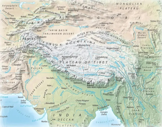
The Himalaya are the world’s tallest mountain range, covering 595,000 sq km/229,700 sq mi, They contain the world’s tallest hundred peaks (all over 7,200 m/23,600 ft), the tallest being Mt. Everest, at 8,848.86 m/29,031.7 ft. The name Himalaya comes from Sanskrit, “abode of snow”. They span the countries of Bhutan, India, Nepal, China, and Pakistan. The entire range is caused by the collision of the Indian and Asian continental plates.


Physical map of the Himalaya.

Since 132 MYA and the breakup of the southern continent of Gondwana (named after the Gondi people of India), the Indian subcontinent has been moving northward. Around 50 MYA, moving quickly at 15 cm/5.9 in per year, it encountered the southern margin of Asia. It has continued moving north, raising the Tibetan plateau and several mountain ranges. The Himalaya are the southern margin of this entire, huge uplift zone. The Indian continental plate is still moving north at 67 mm/2.6 in per yr, so the Himalaya are still growing, at an average of 55 mm/2.1 in per year.


Satellite image of northern India, the Himalaya and Tibetan Plateau.

Three major river basins emerge from this giant mountain range: the Indus, Ganges and Brahmaputra. Their drainage basins are home to 600 million people, more than 7.5% of the world’s population. They form a massive climatic barrier, isolating humid, subtropical zones to the south from cold, arid desert to the north. They also create some of the continental reservoir which produces the southeast Asian monsoon, a seasonal climate pattern of annually alternating onshore and offshore weather patterns. In the summer monsoon (May to September), the sun’s warming of the mountainous interior of southern Asia causes large updrafts, bringing moist warm air in from the ocean to the southwest, creating the season’s famously wet, stormy weather. In the winter monsoon (October to April), cooling in the mountains leads to a sustained, months-long downdraft of cool, dry air blowing out onto the Indian Ocean and Arabian Sea.


The tectonic process behind the Himalaya's formation.


Major watersheds of the Himalaya and surrounding region.

The Himalaya are sometimes called the earth’s “third pole”, because behind Antarctica and the Arctic, the Himalaya are the world’s third-largest reservoir of ice and snow. For this reason they form a vital source of water for the surrounding regions—not just the three river basins named before—which is now at risk due to global warming.


Mount Everest.


Also Mount Everest.

Tomorrow: glacial retreat in the Himalaya.

Be brave, and be well.

Saturday, May 28, 2022

365 Days of Climate Awareness 289 – The Siberian Traps


The Siberian Traps are a plateau of basalt—oceanic crust—measuring roughly 7 million sq km/3 million sq mi—a little smaller than Australia--in extent and 4 km/2.5 mi thick in northern Siberia. The term “trap” comes from the Swedish word “trappa”, stairs, referring to the flat, steplike volcanic deposits. They were created by giant supervolcanoes at the then-northern tip of Pangea between 300 and 250 MYA, in several series of eruptions which lasted two million years.


Location of the Siberian Traps, present day.


Siberian Traps location at time of eruption.

Supervoclanoes are on-land mantle hotspots, like Hawaii or Iceland, but beneath continental crust. Beneath the ocean they form part of the global spreading ridge system, and are erupting more or less continually. But on continents, the heat and pressure from magma and steam can build up for an initially explosive eruption before continuing to produce flood basalts. There is evidence of such ancient volcanoes in the United States—the smaller Columbia River basalts of Oregon from 200 MYA—and Yellowstone is a live modern example, though it’s likely significantly smaller than the ancient Siberian vent(s).


The Traps and neighboring coal deposits.


Paleo-carbon dioxide record (note the spike between 300 and 200 MYA).

These volcanoes emit a low-viscosity (flowing freely) lava which becomes basalt, the dense rock of the ocean floor (this is why Hawaiian eruptions become rivers of lava, and not the towering ash clouds of explosive volcanoes like Mt. St Helens or Vesuvius). The volcanoes of ancient Siberia erupted a staggering amount of fluid which spread across the land and likely the ocean floor, extending the continent with awesome horizontal rock formations. Modern research shows, however, that the Siberian eruptions might have been rather less viscous than most eruptions of this sort, with a greater pyroclastic, ash cloud component, which would have caused worse immediate climate disruption.


Schematic of a supervolcano.


Basalt cliffs in Siberia.

These mammoth eruptions led to the end of most life on earth. As much as 96% of all marine species and 70% of land species went extinct. The cause of the Permian-Triassic extinction (known by other names like the “Great Dying”) has long been a mystery to paleontologists. Current theory assigns several levels of cause to the Siberian eruptions. First was the intense global cooling due to the ash clouds from repeated eruptions. Second was, after the ash clouds had dissipated—a matter of a few years—giant coal deposits in the vicinity caught fire and added billions of tons of carbon dioxide to the atmosphere, warming the planet and acidifying the ocean. This process continued for two million years and caused the greatest extinction known in the geologic record.


More Siberian basalt, cut through by a river.

Tomorrow: the Himalaya.

Be brave, and be well.

Friday, May 27, 2022

365 Days of Climate Awareness 288 – Introduction to Asia


Asia is the world’s largest continent, covering 44,579,000 sq km/17,212,000 sq mi, about 30% of the world’s land area (8.7% of the globe’s surface), and holding 4.7 billion people, about 59% of the world’s total population. It contains the world’s largest country by area, Russia, and its two most populous countries, China (1.413 billion) and India (1.409 billion), which together comprise 35% of the planet’s total population. It is home to the world’s tallest mountain range, the Himalaya, which are still growing due to the Indian continental plate’s ongoing tectonic collision. Asia contains 55 countries, of which 49 are UN members, 1 is an observer, and four are nonmembers.


The dominant religions, each practiced by roughly a quarter of the population, are Islam and Hinduism (Christianity is sixth, at 7%, behind atheism, Buddhism and folk religions). The boundary between Europe and Asia is commonly marked by the Ural Mountains, created roughly 300 million years ago by the collision of Baltica (proto-Europe), Kazakhstania and Siberia. It is then traced through the Caspian Sea, Caucasus Mountains, Black and Mediterranean Seas, incorporating the Arabian Peninsula and Indonesia.  It spans both hemispheres, from the southern tropics up to the northern Arctic.


Continental boundary between Europe and Asia.

Part of Asia, including eastern Siberia and the Kamchatka Peninsula, is actually on the North American continental plate. Asia contains six of the world’s major rivers: the Tigris and Euphrates draining the mountains of Turkey and Iran, and the Ganges, Indus, Yellow, and Yangtze, which all emerge from the Himalaya. The Himalaya are home to mountain glaciers totaling 10% of the world’s total fresh water.


Global Tectonic Boundaries (note boundary in upper right between the North American and Eurasian plates. Alaska and eastern Siberia are North American).


Satellite mosaic photo of a portion of the Himalayan range.

Siberia, one of the world’s most intimidating and unexplored regions, is the site of massive basalt deposits known as the Siberian Traps. These were produced by gigantic hotspot volcanoes, like Yellowstone but possibly much bigger, which erupted over the course of two million years, building the Siberian plateau and changing the world’s climate irrevocably.

Tomorrow: the Siberian traps.

Be brave, and be well.

Thursday, May 26, 2022

365 Days of Climate Awareness 287 – Climate Change and the Arab Spring


The Arab Spring was a series of protests, riots and armed uprisings throughout the Arab world which began in Tunisia in December 2010, and spread east across North Africa and into the Arabian Peninsula, lasting until December 2012. The term “Arab Spring” was adopted from the European “Springtime of Nations” revolts of 1848, and the 1968 “Prague Spring” uprising when Czech Jan Palach set himself on fire.

In similar manner, the Arab Spring began on December 17, 2010, when Tunisian street vendor


Mohamed Bouazizi self-immolates in protest of economic injustice, December 17, 2010.

Mohamed Bouazizi set himself on fire in protest after his equipment was confiscated by a local official with whom he’d been in conflict for quite some time. His act of self-destruction ignited a massive wave of anti-government activity throughout the entire Arab world, culminating in 2011-12 in armed uprisings in Bahrain, Libya, the United Arab Emirates (UAE), Yemen and elsewhere. In early 2011 weeks of massive demonstrations in Egypt succeeded in forcing the resignation of acting president Hosni Mubarak, leading to widespread celebration. Several countries declared states of emergency. It spurred civil wars in Libya, Syria and Yemen. Saudi Arabia violently crushed protest in its own country and lent armed support to Bahrain. The re-assertion of governmental control since then has been referred to as the “Arab winter”.


Effects of the Arab Spring.

Several different factors enabled the protests and uprisings to sweep through that part of the world so quickly. One was social media, with sites like Facebook, Twitter and others allowing people to communicate, spreading ideas and making plans (not the last time those websites would prove dangerous to governments). Another was one of the main drivers: the 2010-11 global spike in food prices.

A 100-year drought in 2010 in China devastated its wheat crop, and combined with shortages from other drought-stricken areas of the planet. Through 2010 and 11, the Middle East, home to the world’s top nine per-capita wheat importers, especially suffered.  After nearly two years of declining regional food production, the global shortage created a crisis. In Arab countries, where governments heavily subsidize many necessities and exert generally greater economic control than in most western democracies, governments were the target of the people’s rage.


Celebration in Egypt after the resignation of Hosni Mubarak, February 11, 2011.

Analogously to hurricanes and extreme events, definitive proof that the warming planet caused the droughts which precipitated the Arab Spring protests and uprisings cannot be given. But the events are easily correlated. In huge, complex physical systems like earth’s climate, and in huge, elaborate, intricate human-made systems like the economies and governments of the world, definitive, quantitative answers are beyond our reach.


Sanaa, Yemen 2015. The effects of civil war, aided by Saudi Arabia.

Is anthropogenic global warming happening? Unequivocally yes. Can global warming be definitively linked to the wave of protest and violence which engulfed Arab countries in 2010-12? No. But the circumstances make the correlation obvious. And since the world is not a laboratory, a correlation as powerful as this should be enough to inspire action.

Tomorrow: introduction to Asia.

Be brave, and be well.

Wednesday, May 25, 2022

365 Days of Climate Awareness 286 – The Middle East and Climate Change


Climatically, the Middle East is already the hottest region on earth and it will only become hotter in years to come. Political and social divisions  have led to a series of regional wars. This combined with the world’s overwhelming desire for oil continue to prevent any semblance of a meaningful climate response there. Models predict warming of 4.0°C/7.2°F by 2100, rendering nearly all of the Arabian Peninsula, and much territory outside of it, uninhabitable.


Political map of the Middle East.

Water wars have already occurred in the Middle East, beginning in the Arab-Israeli War of 1948-9, which resulted in the strategic water source of the Golan Heights being declared demilitarized. Israel proceeded with a water diversion project, to which Syria objected but the US and UN lent their support to Israel, supporting water diversion for both Israel and Jordan. Conflict between Israel and the surrounding Arab nations simmered for nearly two decades, and came to a head again in 1964 when Israel finished its water diversion project in the northern Sea of Galilee. The Arabas attempted to divert fresh water upstream from the Israeli construction, but their efforts failed and led to the Six-Day War in 1967, resulting in an Israeli victory.


The Golan Heights and surrounding area.

Wars like these are the future of an increasingly hot and dry Middle East. But as seen elsewhere around the world, problems cascade and become large-scale disasters. In the case of the Middle East, even longer and hotter dry summer seasons, creating more power demand for air conditioning and reducing crops, will combine with less overall access to water and lead to heightened social instability. Restive populations agitating against their own governments, even while conflict among nations for shrinking water resources increases, could produce a very grim reality in the Middle East before century’s end.


Tomorrow: climate change and the Arab Spring.

Be brave, and be well.

Tuesday, May 24, 2022

365 Days of Climate Awareness 285 – Introduction to the Middle East


The Middle East is a geopolitical term for a region spanning several continental plates, from Egypt in Africa, through the Arabian Peninsula, including the Levantine coast of the Mediterranean, Asia Minor, and eastward through Iraq into Iran in Asia. The region is spanned by the Fertile Crescent, one of the cradles of civilization, which runs from Egypt north through the Levant, across and down through Mesopotamia along the Tigris and Euphrates. Three of the world’s major religions, Judaism, Christianity and Islam, were born there (and continue to be sources of much of the conflict). The region also, by virtue of the shallow marine deposits of the ancient Tethys Ocean, holds an estimated 55% of the world’s total oil reserves.


Map of the Middle East.


Laurasia, Gondwana, and the Tethys Ocean in between.

The Middle East ranges from 12° to 40°N latitude, and its climate ranges from the hot deserts of Arabia to the temperate Mediterranean climate of Turkey’s mountains. It covers an area of 7,207,575 sq km/2,782,860 sq mi (roughly ¾ the area of the US), and a population of 371 million (about 40 million more than the US). The three largest economies are Turkey, Saudi Arabia and Iran. Many countries, such as Iran, Iraq and the countries of the Arabian Peninsula depend heavily on oil, while Turkey, Israel and Egypt have diversified economies.


OPEC oil reserves, 2018.

Traces of human existence extend back deeply into prehistoric times throughout the entire regions, with major civilizations developing before the Bronze Age (which, like other ages, at different times in different locations). Writing, including cuneiform and Egyptian hieroglyphics, was developed there by 3000 BCE. Later the Phoenicians developed the alphabet, where individual symbols stand for specific sounds, which served as the basis for nearly all writing systems which followed in the western world. (Full disclosure: I nearly became a biblical archeologist. I’m fascinated by this part of the world, and the amazing depth of its history. That’s one of the larger what-ifs of my life.)


Hundreds of ethnic groups have inhabited the region, but it is dominated now by Semites—Arabs, Palestinians and Jews—to the west, Turks to the north, and Iranians (of Persian descent) in the east, to name only a very few. Ethnic, cultural and religious differences have combined with the terrible geopolitics of petroleum to turn the Middle East into a morass of war and violence. Despite the devastation of war and disruption of climate, the world still slouches toward its oil.


Baghdad on the Tigris at evening.


Tehran at night.

Tomorrow: the Middle East and climate change.

Be brave, and be well.

Not-Quite-Daily Climate Awareness The Inflation Reduction Act of 2022

(It might take me a while to find a workable new title. Bear with me.) Now that US President Joe Biden has signed the Inflation Reduction Ac...