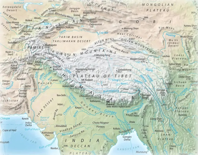
The Himalaya are the world’s tallest mountain range, covering 595,000 sq km/229,700 sq mi, They contain the world’s tallest hundred peaks (all over 7,200 m/23,600 ft), the tallest being Mt. Everest, at 8,848.86 m/29,031.7 ft. The name Himalaya comes from Sanskrit, “abode of snow”. They span the countries of Bhutan, India, Nepal, China, and Pakistan. The entire range is caused by the collision of the Indian and Asian continental plates.
Physical map of the Himalaya.
Since 132 MYA and the breakup of the southern continent of Gondwana (named after the Gondi people of India), the Indian subcontinent has been moving northward. Around 50 MYA, moving quickly at 15 cm/5.9 in per year, it encountered the southern margin of Asia. It has continued moving north, raising the Tibetan plateau and several mountain ranges. The Himalaya are the southern margin of this entire, huge uplift zone. The Indian continental plate is still moving north at 67 mm/2.6 in per yr, so the Himalaya are still growing, at an average of 55 mm/2.1 in per year.
Satellite image of northern India, the Himalaya and Tibetan Plateau.
The tectonic process behind the Himalaya's formation.
Major watersheds of the Himalaya and surrounding region.
The Himalaya are sometimes called the earth’s “third pole”, because behind Antarctica and the Arctic, the Himalaya are the world’s third-largest reservoir of ice and snow. For this reason they form a vital source of water for the surrounding regions—not just the three river basins named before—which is now at risk due to global warming.
Mount Everest.
Also Mount Everest.
Tomorrow: glacial retreat in the Himalaya.
Be brave,
and be well.


No comments:
Post a Comment