Whether the model covers the entire globe, or only a portion of it, the area of interest is divided into a spatial grid, not only horizontally but vertically, incorporating ocean depths and the upper atmosphere. At “time zero” (t0 or tinit), the baseline from which the climate model begins running, the boundary conditions and the world’s initial temperature values are called “primary conditions”. This name simply refers to the state of the system—the values of all the system variables, including temperature—at the outset of the model run.
Lateral and vertical model gridding, over both land and sea.
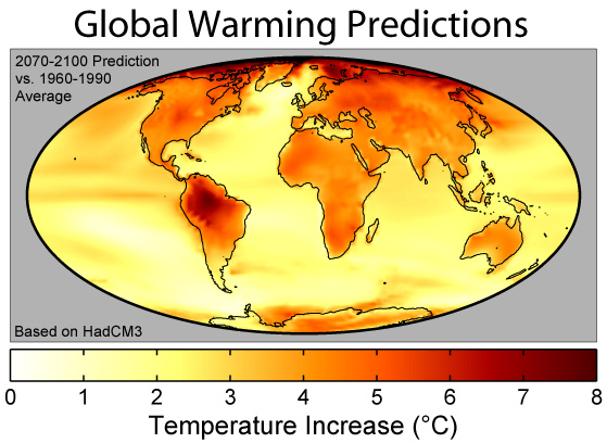
Climate models’ final output is generally a gridded (mapped) set of predicted temperatures around the globe: one complete map for each time step, from beginning (t0/tinit) to end (tn, or tfinal). At the end of each time step, once the map has been completed, the updated temperatures across the entire map grid are loaded back into the equations along with the preset boundary conditions for the next time step, and the model is run again. This process continues, through each time step, until the finish time (January 1, 2100, or otherwise) is reached. And that concludes one run of the model.
Improvements in grid resolution over the years.
There are dozens of models around the world, some focusing on the atmosphere, some on the oceans, some on the atmosphere, some including societal and economic components. Part of the role of the Intergovernmental Panel on Climate Change (IPCC) is to evaluate the different models and integrate their results into one comprehensive set of predictions for the periodic Climate Assessment. The present assessment is #6 (AR6) and is now available online in final draft.
Results of a one hundred-year difference model.
Tomorrow: hindcasting.
Be brave, be steadfast and be well.


No comments:
Post a Comment