Sea ice is ocean water which freezes directly into a
floating surface, as opposed to glaciers, which form on land from precipitation
(snow and rain) and occasionally flow down to the ocean. Sea ice is very thin
compared to glaciers, ranging from a few centimeters to 3-5 m in thickness,
versus 50+ m for flowing glaciers. Sea ice is fresh, as water does not include
salt in its crystal packing structure. The formation of sea ice leaves saltier
water behind.
On average, sea ice covers roughly 7% of the earth's surface, though there is large seasonal variation. To an extent these fluctuations are balanced from north to south, but increasingly, since the north pole is open ocean, northern summer ice loss is not compensated by southern winter ice gain, due to the increasingly large fluctuations in the Arctic, even as the Antarctic appears to be gaining sea ice.
Sea ice schematic.
Ice can form either when attached to the shore, where it is called landfast or "fast" ice, or at sea, where it is called drift ice. Fast ice is physically more stable, much less prone to cracking and breaking into floes than the ice over deeper water (though tides can destabilize the ice cover). The boundary between fast and drift ice is called the shear zone, where wind stresses induce the ice to fragment into floes. Where the floes are densely gathered they are sometimes referred to as pack ice.
As it survives successive melt seasons, sea ice tends to gain in thickness and density. Older drift ice further out toward the deep water undergoes a number of stresses, including wind, shear stress from the ocean currents underneath, and the Coriolis effect which serves to bend the ice back around itself on the ocean surface and create cracks. For these reasons sea ice is an inherently dynamic environment.
We measure a number of environmental variables, including temperature and rainfall, by the concept of "anomaly", which is the numerical difference from a set mean. The mean value is arbitrary, but is generally chosen with judgment and must of course be disclosed to be of scientific value. This is a form of "normalizing" data, that is, dividing measurements by a mean value (in this case, subtracting the mean value), so as to make interpretation easier (because the numbers are smaller and easier to picture). Sea ice extent is analyzed in this way, and data series spanning several decades have been averaged and converted to these anomalies, showing annual sea ice extent differences, whether greater or smaller, from the multi-decadal mean. Arctic anomalies have plunged while Antarctic anomalies hae gained, though not enough to offset loss in the Arctic.
Median annual sea ice extent, Arctic & Antarctic.
One distinctive feature of sea ice is the polynya
(transliterated from Russian), a small spot of open water surrounded by ice.
These can occur near to shore, as the result of current activity, or father
from shore, as the result of wind stress. They can be critical to ocean
dynamics, such as in the Antarctic, where polynyas appear, and while they
exist, are the spots where Antarctic bottom water is formed. Water which both
evaporates and then begins to freeze. After surface water has frozen the
remaining, saltier water is dense enough to sink to the sea floor, and begin
moving north. Antarctic bottom water is one of the major water masses in the
Atlantic Ocean.
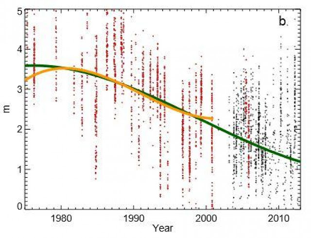
Average arctic sea ice thickness, 1975-2013.
Of increasing concern as we monitor the state of the oceanic cryosphere is not only the extent, but the thickness, of sea ice. This is more difficult to sample as it cannot be inferred effectively by satellite, as can extent, but sampling programs have shown that on average Arctic sea ice thickness has diminished almost one full meter in thickness, from 3 to 2 m.
Antarctic polynya.
Tomorrow: snowball earth.
Be well!


No comments:
Post a Comment