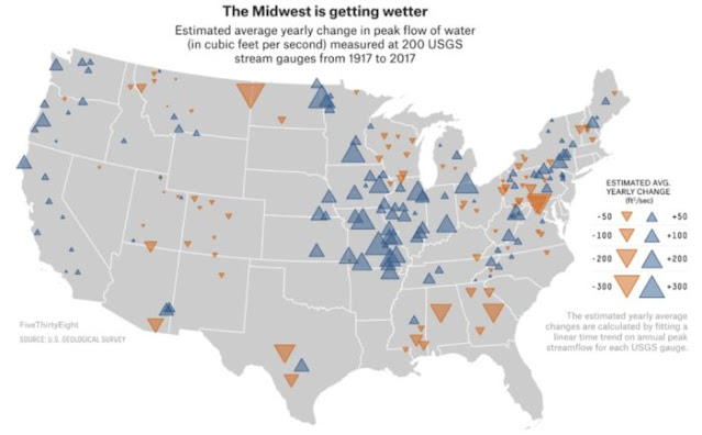
Preciptiation—rain and snow (largely)—is mostly a function of the vapor content in the air. When a given parcel of air is 100% saturated with vapor, it precipitates, or emerges into solid or liquid form, and when the droplets or particles become large enough, they fall. In a world of rising greenhouse gas concentrations, “…warming increases the atmospheric water-holding capacity…[and] results in an increase in extreme precipitation at a similar rate at the global scale.”
Regionally—on a sub-continental scale—factors such as wind patterns, vegetation, sea surface temperatures (SSTs) and regional oscillations such as ENSO and the NAO play large roles. The dynamic aspect of extreme events in general is what makes them difficult to correlate to global warming, further when global warming itself is affecting the dynamics. (A system which feeds back into itself, whether positively or negatively, is said be be behaving in a mathematically “nonlinear” fashion. And nonlinear systems can be extremely hard to predict.) The constant is an atmosphere more capable of holding water vapor, leading to larger potential rain and snow events.
Specifically, rising SSTs play a consistent role in rising
precipitation along the coasts and other impacted regions (such as inland, with
monsoons). This is akin to the rising vapor capacity (evaporative demand) of
the atmosphere: increased SST means the water is at a higher energy state and
more prone to evaporate, leading to increased water vapor in the air and
increased likelihood of storm-generating convection currents.
Per AR6.WG1, it is “likely the number of heavy precipitation
events over land had increased in more regions than it had decreased, though
there were wide regional and seasonal variations…” Specific events, due to the
local dynamics which create them, can be difficult to ascribe directly to
global warming, even with an extremely strong driver such as anomalously hot
air or ocean water.
Tomorrow: tropical cyclones.
Be brave, and be well.


No comments:
Post a Comment