
New Zealand is a nation comprised of two main islands, separated by the dangerous Cook Strait, and located between the Pacific and Indian-Australian tectonic plates. It extends from 178° to 166°W longitude, and from 34° to 48°S latitude, and covers 268,021 km2 (103,500 mi2), about the same area as Colorado. New Zealand features an incredible range of habitats for such a small area, from glacial mountain valleys, to volcanoes, to plains, temperate rainforests and sunny (if not quite tropical) beaches. The islands are tectonically active, straddling a major fault. Most of the two islands fall under one Köppen classification: Cfb-temperate, no dry season, warm summer. The indigenous Maori, of Polynesian descent, arrived via canoe in the early to mid 1300’s CE.

Equatorial waters which flow west through the Pacific, and then south along the east coast of Australia, create an anticyclonic (counterclockwise in the southern hemisphere) between that continent and New Zealand. The warm subtropical water also circulates eastward around the island’s southern tip, shielding it from the colder Antarctic Circumpolar current farther south.


Australia itself is bordered to east and west by warm southwardly-flowing currents, the Leeuwin on the west and the East Australian on the east. Flow on the tropical northern coast is complicated by nearby Papua New Guinea and the Indonesian Islands to its west, but the general pattern is westward and is called the Indonesian Throughflow.
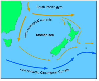
Ocean currents around New Zealand.

Ocean currents around Australia.
Tomorrow: recent Australian temperature and precipitation trends.
Be brave, and be well.


No comments:
Post a Comment