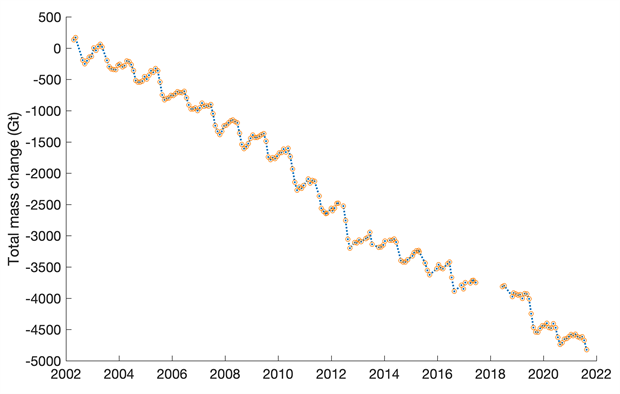
Several different organizations, both public and private, monitor the Greenland ice sheet with instruments and personnel. It is considered a bellwether for the state of the Arctic, and the cryosphere (everything frozen on earth), and the state of our effort to avoid catastrophic climate change. To that end, the news is not good. The ice sheet has lost mass at an increasing rate over the past three decades, though as a rough estimate of the total, a little over 0.1% has melted. Were the entire ice sheet to melt, it would add roughly 7.4 m to global sea level. To this point it is estimated that the Greenland ice sheet has added about 1 cm of depth to the ocean.
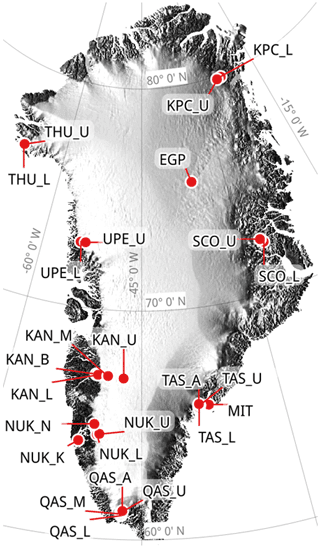
PROMICE (Copernicus) ice monitoring stations.
Copernicus mass loss data, 1980 on.
Groups which conduct monitoring programs include GLISN (the Greenland Ice Sheet Monitoring Network and PROMICE (Programme for Monitoring of the Greenland Ice Sheet), both sponsored by the governments of Denmark and Greenland; the Copernicus program of the European Space Agency; and from the US, the NSF (National Science Foundation), the NSIDC (National Snow & Ice Data Center), and NOAA (National Oceanographic and Atmospheric Association). They use remote sensing from satellites and airplanes, as well as in-situ measurements to track changes in ice mass and melt rate.
NOAA ice loss data, 2002 on.
2018-19 ice anomaly (gain/loss), mm.
Weather stations on the ice measuring temperature, humidity and wind speed and direction provide much closer detail than any remote sensing. Old-fashioned methods such as manual transects, even updated with GPS and lasers, provide critical ground truthing—on-site verification—of satellite and airplane measurements. The combined networks, both close-up and remote, of several different groups provide a clear overall understanding of the condition of this ice sheet which sits at the boundary between arctic and temperate planetary zones.
Ice cap summit camp.
Remote ice monitoring station.
No location on earth exists in isolation. There is no sequestered test case. Greenland is bordered by the Arctic Ocean, the Labrador Current to the west, and the North Atlantic Drift to the east. Polar easterlies blow across the northern half of the island, and mid-latitude westerlies across the south. The Atlantic is an important poleward conduit of heat, and conversely of recirculation of cold back toward the equator. Greenland sits at the nexus of this circulation, which is why it receives special emphasis as we track the warming effects we are having on global climate.
Glacial melt water.
Tomorrow: introduction to Europe.
Be brave, and be well.


No comments:
Post a Comment