Climate models must mimic the observed data. Using the basic fluid dynamics equations (Navier-Stokes and continuity) as a foundation, models attempt to reproduce, in simplified form, not only the basic patterns we have observed, but shorter-term variations. This type of resolution in time and space gives the models enough fidelity to reality to then model long-term trends, over timescales of a century or more.
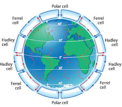
Global wind circulation cells.
In an earlier post (#38, Global Wind Circulation Cells) we looked at the combined influence of uneven heating between equator and poles and the earth’s rotation to produce a series of bands, segregated by latitude, of easterly (from the east) and westerly (from the west) winds. The story of global climate starts here, because even though the ocean contains more than twenty times as much heat as the atmosphere, the bulk of ocean currents are wind-driven, and winds are driven by uneven heating across the earth. The wind-driven currents, like the Gulf Stream and North Atlantic Current, set up the thermohaline (density-driven, vertical) currents where warm water evaporates and the resulting, cooler ocean water sinks.
What you might think wind patterns would make the ocean do (left), versus what happens when you include the Coriolis effect distorting the gyre: western intensification.
A fundamental characteristic of ocean currents is that they tend to be narrower and more intense on the western edge of the ocean basin, but slower and broader on the eastern side. This is due to the combined effects of the Hadley (tropical, easterly) and Ferrel (subtropical, westerly) wind cells which combine to create major ocean gyres around the world. The ocean water, pushed against a continent like North America by the easterly trade winds, is then forced north (to the right) by the combined influence of the Coriolis effect and the continent blocking westward flow.
General concept of the ocean circulation system.
The Coriolis effect gains strength as you move away from the Equator and toward the poles. So the westerly (Ferrel cell) winds, being at a higher (more poleward) latitude than the tropical trades, push the water harder to the south (right). The eastward portion of the wind-driven ocean current acquires a more gently, consistently southward bend and the overall ocean gyre takes on an imbalanced look. The westward, tropical arm of the gyre is driven into the continental shelf, where it is diverted poleward by the shallowing land mass.
Any general circulation model, the type used for climate
simulations over the course of years or decades, begins with these basic
concepts: the latitude-constrained wind cells, and the wind-driven ocean gyres
which are intensified on the western edge when bordering a continent. Together
they constitute a “first-order approximation”, that is, a general but
inaccurate model which needs to be tuned with more specific information.
Tomorrow: Adding detail to a climate model.
Be brave, be steadfast, and be well.


No comments:
Post a Comment