Wednesday, March 23, 2022

365 Days of Climate Awareness 223 – Introduction to the Philippines


The Philippines are an archipelagic country in southeast Asia, bordered to the east by the Philippine Sea (western Pacific Ocean), and to the west by the South China Sea. It is composed of roughly 7,640 islands, mostly within volcanic arcs created by oceanic plates to east and west subducting beneath the intermediate Philippine Mobile Belt microplate. The region is extremely active tectonically, both with earthquakes and volcanoes. It extends about 300,000 km2/120,000 mi2 (a little less than New Mexico), with a population of roughly 109 million people.


Southeast Asia and the Philippines.


The nation is entirely tropical, extending from 4° 40' to 21° 10' N latitude, and from 116° 40' to 126° 34' E longitude. It is bordered on both sides by ocean trenches as deep as 10,000 m/32,800 ft. The climate is nearly all tropical, with temperatures ranging between 21°C/70 °F and 32°C/90 °F. The ocean water is consistently very warm, averaging 29°C/84°F annually near Manila.  The islands are quite mountainous, the highest peak being Mount Apo, 2,954 m/9,692 ft, on the island of Mindanao.


Köppen diagram of the Philippines.


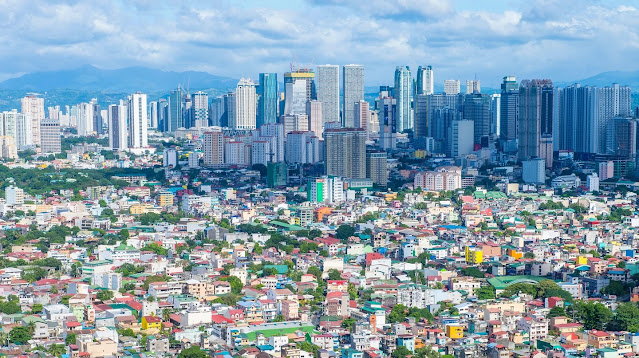
Manila, capital of the Philippines.

The islands received the name “Philppines” from Spanish explorer Ruy López de Villalobos, who named them after King (at the time Prince) Philip II of Spain. The Philippine islands contain some of the oldest proto-human fossils known, including homo luzonensis (est. 67-50 KYA) and Tabon Man (47 KYA). Austronesians arrived between 2200-2000 BCE, and by 1000 BCE had developed several distinct societies.


Map showing the magmatic (volcanic) arcs composing the islands, and the marine trenches to either side.


Cross-sectional view of the Philippines system looking north, with subduction to east and west, and Philippines microplate in the center.

The Spanish began colonizing the area in 1565 and fought to retain control through the late 1800’s, when the First Philippine Republic declared its independence from Spain in 1898 and Spain ceded control to the United States after the Spanish-American War. The Americans imposed a colonial government which remained in place until the Japanese invaded during World War II. Following the war, the Treaty of Manila made US recognition of Philippine independence official.


Some smaller Philippine islands.

Tomorrow: the Philippines and climate change.

Be brave, and be well.

Tuesday, March 22, 2022

365 Days of Climate Awareness 222 – Moving Jakarta


Indonesia’s capital of Jakarta is sinking below sea level, at roughly twice the rate of other large coastal cities worldwide. Sea level rise is one factor but local subsidence due to groundwater removal is the other. Since 2000 parts of North Jakarta have been sinking by as much as 25 cm/year. At this rate 95% of North Jakarta will be underwater by 2050.


Indonesia, Jakarta and North Jakarta.


Jakarta downtown.

Jakarta sits on the northwest coast of the island of Java. It is the largest city in southeast Asia, covering nearly 10,000 km2/3900 mi2, with a population of over 10 million people. It is second only to Tokyo globally in overall area. Jakarta’s population has swelled in recent decades due to the economic opportunity there compared to anywhere else in Indonesia. It is this population boom which has led to the city’s current problem.


North Jakarta.

1977 subsidence model of Jakarta. Light blue = 0-1 m of subsidence. Each zone of successively darker blue = one added meter of subsidence.


Overuse of groundwater is the proximate cause of land subsidence, and the Indonesian government is unable to effectively limit it. Alternate sources of water are either insufficient or heavily polluted, meaning locals have no choice but to keep draining the aquifer beneath the city. The extreme amount of subsidence plus sea level rise makes seawalls and other solutions impractical. While the subsidence is most extreme in North Jakarta, it is severe elsewhere as well: 15 cm/year in West Jakarta, 10 cm/year in East Jakarta.


2025 subsidence model of Jakarta. Light blue = 0-1 m of subsidence. Each zone of successively darker blue = one added meter of subsidence.


2050 subsidence model of Jakarta. Light blue = 0-1 m of subsidence. Each zone of successively darker blue = one added meter of subsidence.

This reality led Indonesian President Joko Widodo to announce in 2019 that the government was making plans to move the capital. Three cities have been under consideration, while funding is secured and possible sites are evaluated.

Tomorrow: introduction to the Philippines.

Be brave, and be well.

Monday, March 21, 2022

365 Days of Climate Awareness 221 – Indonesia and Climate Change


Oil was discovered in Indonesia in the late 1800’s. The country joined OPEC in 1961 but suspended its membership in 2009 after years of production declines (briefly reactivating and then deactivating its membership again in 2016). From the 1960’s through early 2000’s Indonesia was a net oil exporter, but falling production and rising domestic consumption turned it into a net oil importer, which it has remained ever since. (Indonesia, along with countries like the United States, is thus an excellent example of geologist Jeffery Brown’s “export land model” of crude oil production versus consumption, the topic of a future post.)


Crude oil production and consumption in Indonesia, 1967-2020.


Natural gas production and consumption in Indonesia, 1970-2020.

Along with rising petroleum consumption have come rising emissions of carbon dioxide. Indonesia’s raw total and per capita emissions have risen sharply in recent decades, and the country now accounts for roughly 1.8% of the world’s total CO2 emissions, while having 3.5% of its population (280 million out of 7.9 billion). Oil production continues to decline, while natural gas production and fossil fuel production continue to increase.


Indonesia is also one of the world’s leading exporters of coal (currently fourth globally, behind China, India and the US, and just ahead of Australia). While by 2020 renewables rose to 11.2% of the country’s total generation of electricity, as of 2019 coal accounted for 63%. Indonesia’s government plans on expanding coal-fired power generation to bring electricity to its more remote islands.


Average temperature in Indonesia, 1901-2020.

Deforestation is another major source of carbon dioxide for the atmosphere, via the lost forest sink. Between 1950 and 1999 it is estimated that Indonesia’s forests lost 62 million ha/153 million acres, or over 38% of its total area. Palm oil production and urbanization are the main culprits. Though forest loss has slowed in recent years it remains a concern.


Forest loss seems to have slowed but remains a problem.

As Indonesia industrialized and its population expanded in the late 20th century, temperatures have risen but not markedly. This is consistent with the global pattern of less dramatic effects near the equator, where increases in thermal energy are proportionally lower than near the poles. Mean temperature was fairly even through most of the 20th century, with the 0.5-0.75°C/0.9-1.4°F increase coming mostly since 1970. As with other island nations, Indonesia’s main concern is with sea level rise.

Tomorrow: moving Jakarta.

Be brave, and be well.

Sunday, March 20, 2022

365 Days of Climate Awareness 220 – Human Threats to the Reefs of Indonesia


Coral reefs throughout the world are vulnerable to the impacts of human society and, in particular, global warming. These include warming and acidifying water, outside the tolerance of coral polyps. They include excess sedimentation from nearby land, when forests are cut down and replaced by farms or buildings, which results in increased erosion and added sediment being deposited offshore, which can choke the reefs. It includes overfishing, where segments of the reef population are removed for food, upsetting the entire reef’s biological balance and contributing to their death. But there are some human threats  particular to southeast Asia.


The first is the use of explosives, known as dynamite fishing, blast fishing or fish bombing. (It’s what Crocodile Dundee was doing in New York harbor at the start of Crocodile Dundee II. It’s also known to occur in the Philippines, off the coast of Africa and in the Aegean Sea.) Dynamite works well but is expensive and nearly impossible to obtain. It’s possible to achieve the same goals using explosives made from fuel and fertilizer. The fisherman lights the explosive and tosses it in the water. When it explodes, the pressure wave kills most fish within the vicinity (depending on the size of the charge) by rupturing their swim bladders. The fishermen are then free to harvest and sell the dead fish.


Dynamite fishing.


The catch.

The practice is extremely destructive to all life in the area (including, sometimes, those of the fishermen). The pressure wave kills or wounds most animals, and can badly damage macroscopic algae. The immediate area of the detonation can leave craters in the structure of the reef. Enough blast fishing will kill a reef community. The practice is more common on smaller, hard-to-patrol islands where fishermen can work with near impunity. Local activists trying to end the blast fishing stress that it is not a subsistence practice. Rather, the practice brings significant wealth to the ones who organize it.


The damage.


Cyanide fishing.

Second is cyanide fishing, common in the coral triangle because of the spectacular diversity and appearance of the fish. It is a practice aimed at producing live exotic animals as pets for collectors worldwide. The fisherman swims underwater with a squirt bottle full of cyanide (CN-) solution, and then squirts a cloud of it in the vicinity of the target fish. If done skillfully, the fish is stunned and is easily bagged by the fisherman, live, for later sale and transport. Like blast fishing, cyanide fishing is common in the more remote island coasts of Indonesia, the Philippines and the surrounding islands. As long as there is a wealthy market for exotic fish, and as long as the reefs continue to exist, cyanide fishing is likely to continue.

Tomorrow: Indonesia and global warming.

Be brave, and be well.

Saturday, March 19, 2022

365 Days of Climate Awareness 219 – The Coral Reefs of  Indonesia


Of Indonesia’s 2,915,000 km2/ acres of ocean area, 51,020 km2/acres, or 1.8% of the total marine area, is take up by coral reefs. Scientists estimate that 17% of the world’s coral reefs are in Indonesian waters. Biologists estimate more than 500 species of coral, both soft and hard, live there.  Coral reefs support an immense amount of biodiversity, including 33% of all fish species, and are the spawning ground for 25% of all marine species. Indonesia’s are considered to be the most biodiverse on the planet.


The Coral Triangle.

Indonesian territory makes up the center of what is known as the “coral triangle”, the marine region of southeast Asia and northern Australia (though not including the Great Barrier Reef). The triangle includes the neighboring countries of Malaysia and Brunei, the Philippines, and several nations in Melanesia. A number of them including Indonesia have banded together into the Coral Triangle Initiative, a joint program between governments to preserve the coral reef ecosystems.


A healthy area of Indonesian coral reef.

Several theories exist as to why species diversity is so great throughout that region: more than 3,500 different marine species make their home there. Some posit that independent populations from different locations expanded, mingled, and developed more complex ecosystems together. Some theories posit a common origin to the species, with natural evolution leading to the current diversity.


A section of reef in poor condition.

However, a recent survey estimates that only 6.5% of Indonesia’s reefs are in very good condition. It found 36% to be in poor condition, being visibly degraded; 34% are in adequate condition, with most species represented; and 23.5% are in good condition. So roughly one third of Indonesia’s reefs are threatened.

The gravest danger to the reefs’ survival is mostly in the central region of Indonesia, along the coasts of the smaller islands. Global warming threats such as ocean acidification and temperature rise are far from the only problems. Beyond even the widespread overfishing which decimates reef communities around the world, there are some very specific threats in this region which are largely a function of the reefs’ diversity of species.

Tomorrow: anthropogenic threats to Indonesia’s reefs.

Be brave, and be well.

Friday, March 18, 2022

365 Days of Climate Awareness 218 – Introduction to Indonesia


Indonesia is an island nation between Australia and southeast Asia, and the Pacific Ocean to the east and Indian to the west. It counts over 17,504 islands, of which about 6,000 are inhabited, including the larger ones Sumatra, Sulawesi, Java, and some of Borneo and New Guinea. Its population is over 270 million, making Indonesia the most populous Muslim-majority nation on the planet.  The name is from Greek (aren’t they all?), indos (India) + nesos (island), coined by ethnologist James Logan.


Indonesia is the site of some of the oldest hominid fossils on earth: “Java Man”, indicating the area was inhabited between 2 – 0.5 million years ago. Humans arrived roughly 43,000 years ago. Later Austronesian migrants drove the prior inhabitants out around 2000 BCE and make up the dominant modern ethnicity. The Dutch colonized the area in the 1600’s, but were driven out by the Japanese in World War II. In 1945 Indonesia proclaimed its independence, and has veered between democracy and authoritarian government ever since.


Islands in the volcanic Indonesian archipelago.


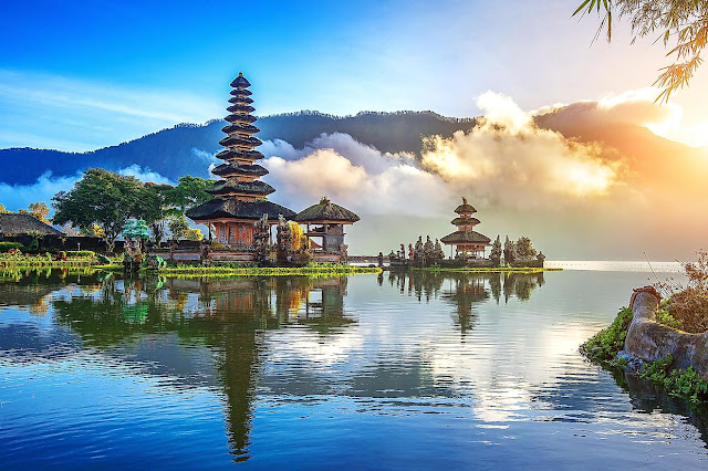
The Pura Bratan Hindu temple, Bali.

The nation’s thousands of islands stretch 5,120 km/3,181 mi E-W and 1,760 km/1,094 mi N-S. It spans the equator and sits across the link between Pacific and Indian Oceans. The region is very active volcanically, including, most recently, Mount  Semeru in Java (Dec. 6, 2021). The current island were once part of a large land bridge when ocean levels were lower during the last glaciation, which is how early migrants passed through and settled the area. The area was drowned with the melting of the glaciers and became the current archipelago.


Köppen-Geiger climate map of Indonesia.


Indonesian Throughflow.

Due to its tropical climate and densely inhabited forests, Indonesia is home to some of the world’s greatest biodiversity both on land and in the water, and contains nearly a third of the world’s coral reefs.  Water tends to move from the slightly higher Pacific westward to the Indian Ocean, in a set of currents known as the Indonesian Throughflow. Its total transport is 12.5 Sverdrups, or 12.5 million square meters per second (for comparison, the volume transport of the Gulf Stream off the southeastern US is 30 Sv, about 2.4 times as much).

Tomorrow: the coral reefs of Indonesia.

Be brave, and be well.

Thursday, March 17, 2022

365 Days of Climate Awareness 217 – Easter Island: A Cautionary Tale


Looking up “Easter Island” online will quickly bring up words like “disaster”, “catastrophe” and “ecocide”. The name “Easter Island” was given by Dutch explorer Jacob Roggeveen, who sighted it on Easter Sunday, 1722. It is an extremely remote island in the subtropical southeastern Pacific Ocean, more than 2,000 km (1250 mi) from the nearest island (Pitcairn), and over 3,500 km (1280 mi) from the nearest mainland, Chile. 

Easter Island, at the southeastern tip of Polynesia.

The island consists of three coalesced, extinct volcanoes. It is debated when Polynesian settlers, the Rapa Nui, first arrived, but likely between 800-1200 CE. Their population reached about 15,000, concentrated mostly on the eastern side of the island, but was down to fewer than 200 by the late 1800’s. The island is now a territory of Chile.


Map of Easter Island (note the multiple craters).

Though it has a tropical rainforest climate, with warm, humid summers and mild winters, the island is virtually treeless. It is best known for the roughly 1,000 monumental statues—the moai—spread throughout it. Their purpose is unknown, but anthropologists theorize they are monuments to ancestors. (I question this, since there are no such monuments (that I’m aware of) anywhere else in Polynesia, and certainly not on this scale.)


Artist's concept of the island, pre-settlement.

Pollen studies indicate that the island was once forested with broadleaf tropical and subtropical trees, especially a large, now-extinct species of palm. However, Polynesian settlers brought their preferred food source, the Polynesian rat, which spread unimpeded. There is little evidence that the rats attacked the trees. Such remains as there are show human agency in the trees being felled, not teeth marks. The trees were cut for building and to create farmland. The rats meanwhile consumed smaller plants and insects, completing the destruction of the Easter Island ecosystem at multiple levels.


Moai on the slope of the crater near the water.

By the late 1800’s the Rapa Nui population had declined sharply to only a few thousand. European explorers cited the environmental ruin of the island, compared to others in the Pacific, and stated (denied by the natives) that the Rapa Nui had turned to cannibalism. Raiders from Chile took away more than 1500 islanders as slaves, leaving only 111 by 1872. From that time on the local population has staged a recovery, numbering about 4500 today (out of 7600 total). Though nominally the ethnic group has recovered, nearly all cultural knowledge of the original settlers is lost. The original Rapa Nui society is dead.


More moai, recently restored to standing position, lining the coast. These don't strike me as simple memorials to earlier generations. The moai found in their native positions face the water--only the modern restorations face inland. Half the statues were still being made in the quarry. This seems less like a gradual, generational practice to me, and more like a desperate rush. I suspect these huge, imposing faces were meant to be guards. Were they a collective pathological response, a panicked society's attempt to protect itself from collapse by means of an invented ritual? Critique away!

There are examples all across the globe of human societies rising, then exhausting their environments to the point that the society collapses. Some, as in the case of Easter Island, are entirely the fault of the people, who made their own home almost uninhabitable. In other cases, such as the Hittite Empire, natural disasters helped. But Easter Island is perhaps the world’s clearest, if tiniest, example of humanity running headlong into the limits to growth.


Rano Kau crater, southwestern tip of the island.

Tomorrow: introduction to Indonesia.

Be brave, and be well.

Not-Quite-Daily Climate Awareness The Inflation Reduction Act of 2022

(It might take me a while to find a workable new title. Bear with me.) Now that US President Joe Biden has signed the Inflation Reduction Ac...