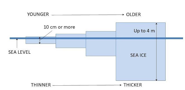
Sea ice in the Arctic is one of the most visible symbols of global warming. It is also the focus of some of the most intense dispute, since ice extent can vary widely from one year to the next, due to a number of important reasons such as incoming water temperature, air temperature, the state of various pressure oscillations such as the North Atlantic and North Pacific Oscillations (NAO/NPO), ENSO and cyclone activity. The trends in Arctic sea ice extent, age and thickness are downward, but unevenly (particularly for extent). The signals are very noisy, so to speak.
Ice extent can be measured easily by satellite via the
albedo. Ice, especially when covered with snow, is far more reflective than sea
water (0.5-0.7 vs 0.06 albedos, respectively). Ice thickness and therefore age
can be inferred via satellite altimetry (worth a post in the near future!).
Important aspects such as ocean and solid earth tides must be accounted for, as
in any high-resolution sea surface altimetric measurements. Once done, the
remaining signal shows varying heights within the Arctic sea ice covering.
Generally speaking, sea ice grows thicker with age. New ice might be 4 inches (10 cm) thick, while years-old ice might be more than 12 feet (4 m) thick. With knowledge of the salinity of the Arctic ocean—which is regularly monitored—it’s a simple matter of math to infer, based on sea level and height of the surface, how far down the ice extends (generally about 90% below the ocean surface), and therefore how thick, and thus how old, it is. Because of ice’s buoyancy in water, thicker ice will at the same time stand higher than thinner ice.
The time series of images were taking on January 1 of each
year (except 2021, which was January 4), and show not only the reduced extent
of overall sea ice but, especially, the disappearance of most multi-year ice.
Not only is ice extent diminishing, but also its thickness—and therefore, even
more so, its overall mass.
Tomorrow: satellite altimetry.
Be brave, and be well.


No comments:
Post a Comment